Monday, December 16, 2013

Eastern Townships 2013, Day 6: Frelighsburg to Yamaska River National Park

< back to day 5 forward to day 7 >
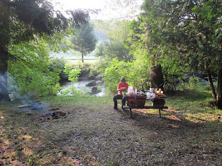
I woke up early to a sunny but misty morning. As it wasn't yet quite a safe time to wake up the biketopus, I spent some time making a fire and watching hectic campground staff cleaning everything thrice in preparation for an upcoming inspection that morning.

Over breakfast, we discussed the plan for rest of our trip. It was clear that we were too far behind schedule to do the original route, especially since our legs were still feeling tired. We had offers from two different Warmshowers hosts but one would have been too close, the other too far away. In the end we settled on riding north to Yamaska National Park near Granby today and then have a long but flat day back to Montreal the day after.
After a few flat kilometers back into Frelighsburg, we were served a mean hill for breakfast. According to the sign on top, it was a 10 per cent grade, but compared to what we had done on previous days it didn't feel too deadly.
The mountains of the Eastern Township were still visible in the distance but our route significantly flattened into gently rolling hills.
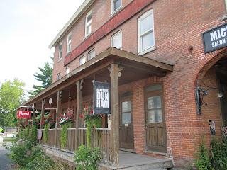
In Dunham we rode past this lovely looking microbrewery/brewpub. Unfortunately, they were closed and at any rate it still would have been a little early for beer.


Instead of beer, we had bread and pastries from a local bakery next door as a second breakfast. I also picked up a paper map and further refined the remaining route to Granby, trying to stay away from busy roads as much as possible.
That plan worked out very well and for the rest of day we would encounter only few cars on these pretty country roads.

Past Cowansville, we turned east for a bit, following one arm of the Yamaska River (somewhat confusingly, the river consists of several tributaries, all having Yamaska in their name). At the turn-off I had spotted a sign for two covered bridges and I thought they would probably make for a good lunch stop. We were riding along for a bit and I was afraid we might have missed the bridge, but finally we saw the sign and shortly thereafter the bridge, Pont Balthazar. Now I must say that I don't quite understand the North American obsession with covered bridges, but this one's location was stunningly beautiful, right over some rocky rapids.


When looking for that perfect lunch spot, I noticed what looked like a turtle in the water below. It was so big, however, that I first couldn't believe it. To a German, turtles are things that live in zoos or on the Galapagos Island, and even while living in the US I had only ever seen modestly sized ones. This one, in contrast was about 40 cm, lazily lying in the water between two rocks.

What more can you ask for for a lunch break -- covered bridge, lovely scenery, amazing wildlife.


Our route continued on tranquil roads before finally we had completed our loop and met up with the Route Verte where we had been riding on our second day.
After passing through Granby again, this time we kept left and headed towards the National Park. Whereas Mont Orford National Park fit the stereotype of a place of untouched nature very well, the park in Yamaska featured landscape clearly shaped by humans. The Yamaska River (yet another tributary) is dammed to form a large freshwater reservoir, surrounded by the park.


When entering the park, we saw signs that there currently was a blue-green algae bloom in the reservoir. No swimming for us -- or anyone else. As a consequence, the park was pretty empty. Instead of taking one of the cyclist camping sites we were assigned a regular spot in the woods. Before the sun set we took the opportunity for a short hike through the forest. As we walking along on a narrow trail,  I suddenly spotted a porcupine sitting in a tree. Mr. (or Mrs.?) Porcupine and I were equally startled for a moment -- seeing a porcupine in the wild was another first for me -- and the biketopus was startled by me making a jump to the side and being like "Whoa! Porcupine!"

Unfortunately, we weren't quite done yet with our wildlife encounters for the day. After dinner, I took a trip to the bathrooms to clean our dishes and do laundry. The biketopus stayed at our campsite and had an unwanted visitor -- a skunk! We had seen them before but this particular one was clearly more curious than afraid of humans and decided sniff the biketopus's toe. Understandably, she was not too thrilled about that! Fortunately, it all ended well, even though the skunk returned later at night, while we were sleeping in the tent to check out my bike shoes under the tent's fly. Well, what can you say: they're black and white and they sure did smell!

< back to day 5 forward to day 7 >

Wednesday, November 13, 2013

Winter Bike Envy

Someone in our household has a badass winter bike. And it's not me.
B&M Lumotec IQ Cyo senso plus front light; no-name front basket

Schwalbe Ice Spiker Performance 559-54 (26x2.1)

Civia Loring with Avid BB5 disc brakes, Shimano Deore LX dynohub, SRAM iMotion 9 IGH


Handlebar Booties

Sunday, October 13, 2013

Did somebody say "gravel bike"? Mont-Tremblant 200k

Riding to Mont-Tremblant, after my previous, unsuccessful attempt, was still on my bucket list, and what better time to do such a ride than during the colorful fall. I had planned a route with a significant proportion of what I assumed would be gravel roads and this being the Laurentians, there was plenty of climbing. In order to be able to cover the distance, I spent Friday night at the McGill Outdoors Club's house in Prevost. After only a few hours of sleep I headed out at 6 o'clock. There were a few signs of the nearing dawn but it was still very dark. Given that it was October, it wasn't too cold -- or so I thought. I had expected for the route to start being mostly uphill. I did gain elevation, but only in the form of a constant succession of steep uphills and screaming downhills. The temperatures were also constantly changing, with the dips around the myriad of lakes being a good 5°C colder than the higher parts. So I'd get sweaty on the uphills and freezing on the downhills. Not too pleasant. Fortunately all other aspects of the riding were great: perfectly smooth lakes, a bit of remaining fall foliage, and the sun slowly getting up to and above the horizon.

The time just before sunrise is just awesome

Ah, finally some sun. But still cold.

The number of quiet, beautiful lakes is huge.

Most of them don't have public access to the lake, but since there are just so many, I still got a bunch of pretty shots

 I had hoped that the first part of the route would be all paved, but the smoothing pavement soon was replaced with horrible pavement and then gravel roads of varying condition. Overall not too bad, though, despite my 25mm tires.
The mountains are getting higher.
 Suddenly the gravel road ended and turned into a trail. Google must have that wrong, as they wanted to route me through here. Fortunately, the trail was actually a designated bike, hike, and cross-country skiing trail, the Sentier L'Inter-Vals. Because the surface was soft and sandy I had to get off the bike a couple of times. Well, this was also a good opportunity for a first short break.
A "Share the Road" sign on this??

 I deviated from my planned route to continue on the trail instead of the provincial highway.
Most of the trail was ridable, yet only at a slow pace. And keeping traction on the steep uphill sections was a challenge.

Stunning views over Lac-Archambault

A little bit of 'cross practice

 I didn't follow the trail for its whole length but switched over to the highway for the last part into Saint-Donat. In town I refueled at an IGA before going into the nice and pretty touristy town center.
I guess nobody walks in winter??
 The next section of the ride, from Saint-Donat to Lac-Superieur had a very different character. After windy, deserted roads through the forest I now followed a wide, straight highway. This was also the first time I saw other cyclists -- this seems to be a popular roadie route.

The climbs were a little gentler, but not much.

A sign that every cyclist loves.

Even a real pass, with a sign...

...and a screaming descent. Vmax=82 km/h

Lac Superieur

 I had planned to take a longer break in Mont-Tremblant. But with only 10km or so to go my energy levels were extremely low and when I saw a lookout/picnic area next to the river I took the opportunity.
Perfect spot for a lunch spot and little nap.
 A sandwich, a bottle of electrolytes, and a micro-nap worked wonders and soon I was on the road again. Mont-Tremblant was extremely busy and I didn't bother going into the actual village part.
Mont-Tremblant

 I briefly considered saving myself what would probably be a challenging part of the route and just continue back on the P'tit Train du Nord trail, but decided against it. It was only 12:30 and my legs were still alright.
On the P'tit Train du Nord/Route Verte
 In Saint-Jovite I left the trail and after a short section on the shoulder of QC-327 I was on quiet country roads again.
A scenic valley after leaving the Route Verte.

 Initially, the roads were paved but in mediocre shape.
Too bad the road was bumpy and there was a 90° turn at the bottom...
 Eventually asphalt turned into gravel again, though.
Rideable gravel

Not so rideable gravel.
 The conditions got worse and worse. I had to get off the bike quite frequently and where I could ride it was slow and jarring. The only other vehicles I encountered were ATV's -- clearly the better choice! Well, there wasn't much I could do and I just continued. At kilometer 180 I finally caught the pinch flat that I'd been expecting. To have two spare tubes and one spare tire was very comforting under these conditions. Finally I got back on paved roads, some of them brutally steep. At this point I had decided that instead of spending another night at the MOC house, I'd try making it back for the last train to Montreal. Not knowing how many hills and horrible roads might still be in stock, this was a bit of a gamble. In Saint-Adolphe-d'Howard I made a quick stop to fill up my bottles and grab a pack of new batteries for the GPS. Downing a ClifBar and a can of coke worked wonders and I made good time on the way towards Saint-Sauveur.
Near Saint-Sauveur, with the evening sun producing wonderful colors

If you zoom in, you can see the moon between the power lines.


 I had to stop at the MOC house to quickly grab my sleeping bag and other stuff. From here it was another 15km to the train station in Saint-Jerome and I arrived with more than half an hour to spare before the train's departure. Total distance was 230 km with about 3500m of climbing. While the climbing was tough, I'd say the parts on horrible gravel roads was actually more challenging. Maybe I need to buy a gravel bike...