I grew up in small-town Germany. Welzheim, my home town, is a city of 10,000 people. It's on the edges of the
Stuttgart metro region (population 2.7 million), about 30 miles from Stuttgart itself. My parents still live in Welzheim, and I visited them for a week this March. And, of course, I rode my bike.
 |
| Lovely small roads make for great biking |
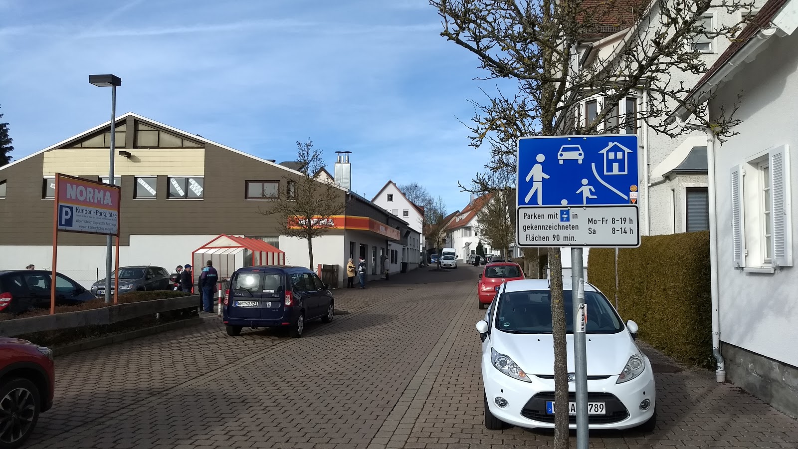
So as Welzheim is in Europe, there obviously is a lot of bike infrastructure, right? And nobody drives a car. Well, note quite. Germany with good reason is known as a nation of cars (Mercedes Benz and Porsche have their headquarters in Stuttgart). And in a small, rural town like Welzheim, there's actually not much obvious bike infrastructure to speak of. There are zero protected bike lanes, bike parking is pretty mediocre, and even on-street bike lanes don't exist, with the exception of an advisory bike lane on two streets. And yet, the biking experience is much better than you'd expect.
Traffic calming is one big reason for this. On most residential streets, the speed limit is 30 kph (19 mph). More importantly, the streets are built so that people by and large actually drive at that speed. The streets by default are much narrower than a typical US residential street. So when a car is parked on the street, two cars generally can't pass each other, keeping speeds down. Further, intersections are usually unsigned, meaning that the person coming from the right has the right of way. Effectively that means that at each intersection you have to be prepared to stop. Actual stop signs, on the other hand, are so rare that my navigation app actually gave me a voice notification the few times that I did encounter one.
 |
| Mail carrier on electric-assist cargo trike |
Traffic signals are also much rarer than in the US. The whole town of Welzheim has not one signal. Roundabouts, on the other hand, are plentiful. Starting in the 1980s, new intersections on busier streets often were built as roundabouts, or old ones were retrofitted. On the 8-mile drive from the nearest train station to my parents' house, you will encounter no fewer than 10 roundabouts. Now in the US, among bike advocates and the general population, roundabouts have a bad rap. Much could be said here, but it's important to note that German roundabouts are built smaller than US ones, and multi-lane roundabouts like the one we have on Mineral Point Road in Madison are very, very rare. More narrow lanes means people driving have to slow down more and aren't tempted to pass people on bikes on the roundabout approaches or in the roundabout.
Some residential streets are designates as "traffic-calmed area," a concept similar to the Dutch
woonerf. Cars must drive at walking speed, and people walking and biking are entitled to the whole street. Again, those streets are usually built in a way that makes it clear that people must drive slowly.
What about commercial streets? Welzheim's main street looks like this:
The speed limit is 20 kph (12 mph), and as a pedestrian you can easily cross the street wherever you like. Through strategic placement of planters or on-street parking spots, there will be locations where two cars can't pass each other, keeping speeds down.
Going one step further, some cities have pedestrian malls in their city centers. This is Schorndorf:
Biking is sometimes restricted in these areas, either banning bikes at specific times or asking people to bike at walking speed. Deliveries by car or truck are permitted only during a short time window each day.
Bike parking is not that great by Madison standards. If there are bike racks at all, they often default to what Germans call the Felgenbieger (rim bender) style of rack. This is probably one reason that kickstands are very common on bikes, allowing people to just park their bike wherever when they go for a quick trip to a shop.
 |
| E-assist bike on a rim bender rack |
 |
| Note the wheel lock on the bike on the right. Good enough for a quick stop. |
At train stations and in larger cities, bike parking facilities tend to be better. For instance, at the Bad Cannstatt train station, there is a "bike station" where you can valet your bike (and also have it repaired while its parked there). With the Judge Doyle Square bike center, Madison is poised to get similar facilities. We'll have to see how well they work without a transit location.
 |
| The bike station is run by a charitable enterprise, training and employing people with disabilities or other challenges |
Once you get out of town, biking can be really awesome. One feature of the region is a dense network of farm or forestry service roads and tracks. For historical reasons, parcel sizes in this part of Germany are very small. This is an aerial image of Welzheim and its surroundings (Image: Google Maps).
All those little strips of fields that you can see are owned by different farmers (and the same is true for forest parcels). And of course that means that each farmer has to be able to get to his or her field. The service roads to get them are public right-of-way, but motor vehicle access is limited to farm traffic.
 |
| Farm road |
 |
| Forest service roads are usually unpaved |
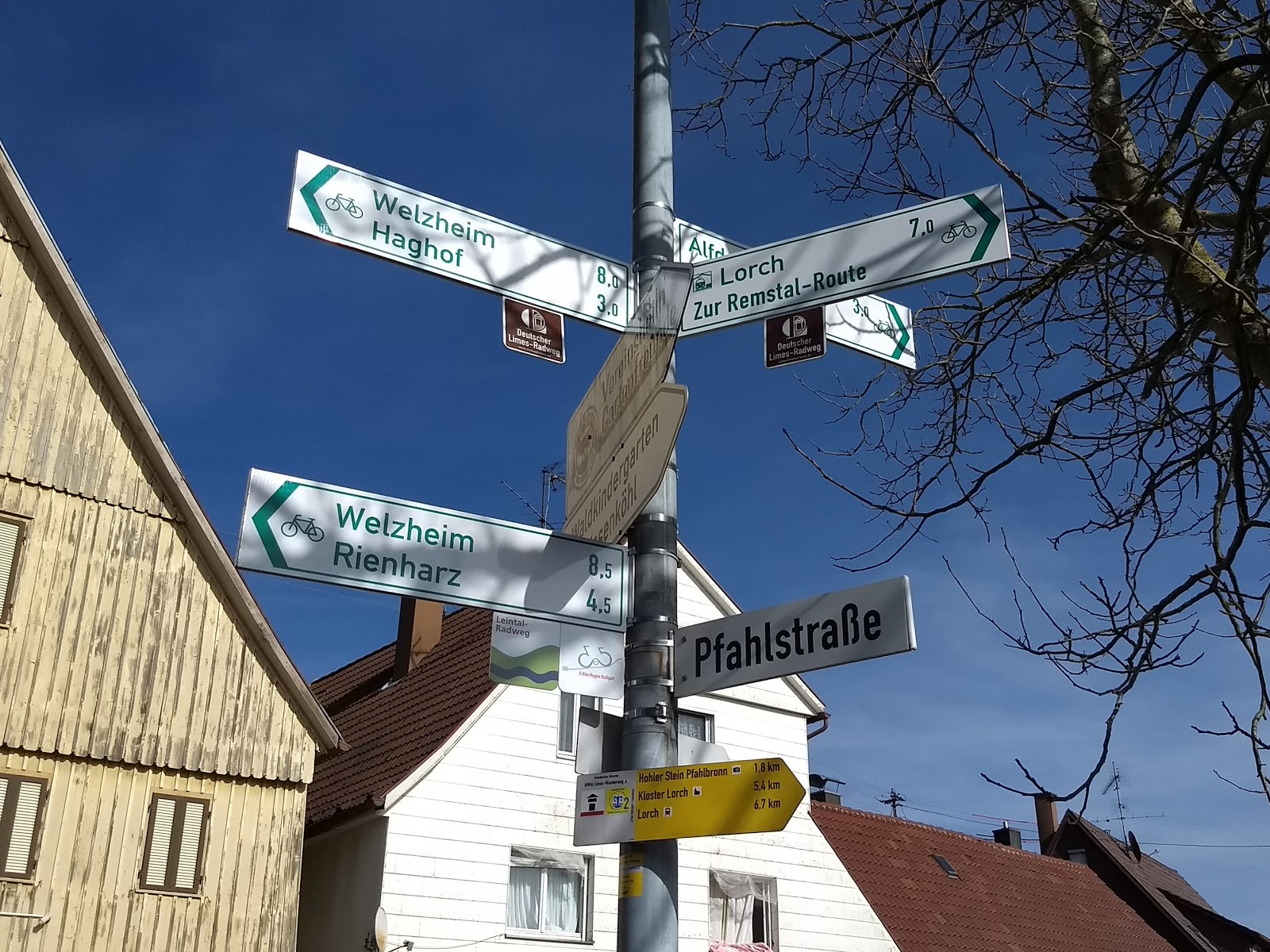
Navigation on these roads and tracks used to be a challenge. There is no orderly grid system, and it could often be hard to tell where any given road would take you. Fortunately, over the past decade or so, communities have made much progress on signing bike routes that string together little pieces of road to connect villages and cities.
 |
| The green signs point show bike bike route destinations and
distances; the small square signs underneath them are for touristic bike
routes; the yellow sign is for hiking. |
I want to be clear that there
are some problems with these routes: Welzheim is in a rather hilly area, and the easiest routes up those hills are often taken up by roads. So if you follow a bike route, you should always be prepared for steep climbs. The routes also do not get cleared of snow in the winter. And finally, sometimes the routes are geared more toward recreational biking instead of providing the most direct route. But overall, they provide an amazing low-stress network for people biking, for recreation and transportation alike.
 |
| Some snow left on this forest road |
Are there any takeaways for bike advocacy in Madison? Obviously some of
the things I have described we can't recreate here. The issue of traffic
calming may offer some lessons, though. Many advocacy efforts here in
the US focus on creating protected bike lanes as a way to enable people
of all ages and abilities to bike. And there are good reasons for that.
But at the same time we shouldn't lose track of the fact that traffic
calming can also create spaces that are great for biking and walking
(and have other benefits such as reduced noise). This applies not only
to residential streets, but also to commercial corridors. This does
require being serious about it, though. Merely slapping a 20 mph speed
limit sign on an otherwise unchanged street is not going to be enough.
And neither is the occasional speed bump or sporadic enforcement.
Diverters that prevent cut-through traffic, reducing the width of a
street, creating bump-outs at intersections--these are some measures
that may transform a street into one that many people will feel
comfortable biking on.
A second takeaway is that good signage can add a lot of value at little cost (financial and political. In a way,
the farm roads in Welzheim are similar to, say, the network of multi-use paths in
Fitchburg.
You can get to many destinations on
those paths. But unless you're really familiar with the area,
navigation is a challenge. Similarly, if you're riding on the
Southwest Path or Cap City Trail, knowing where to turn off to get to
a destination on Monroe or Willy Street is not obvious. Good signage
would help with this. Dane County actually developed a "
Bicycle
Wayfinding Manual" (warning: big pdf) to address this issue,
but implementation has been slow so far.